How to use Conwy's online mapping system
Finding council facilities
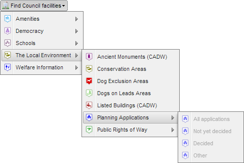
This menu is where you will be able to find a number of types of council information. Rather than have one large list, information has been categorised into smaller lists. If a menu item has an arrow to it's right hand side it means that additional lists (or search options) are available. Please note that these lists will change over time as Conwy enhances the system but the fundamental approach used will be the same.
This menu is where you will be able to find a number of types of council information. Rather than have one large list, information has been categorised into smaller lists. If a menu item has an arrow to it's right hand side it means that additional lists (or search options) are available. Please note that these lists will change over time as Conwy enhances the system but the fundamental approach used will be the same.
In the above image you can see that Planning Applications can be found under The Local Environment option. Planning Applications also have a number of search options available, these are 'greyed out' in this image because they are only available at certain levels of magnification.
An example of finding council facilities
For this example well look at finding a Councillor.
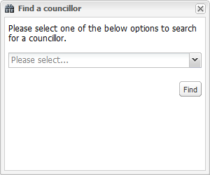
Click on the Find Council facilities menu and then move you cursor over the Democracy option, move your cursor to the right and select the Councillors option, this will display the Find a councillor box as shown below;
For this example well look at finding a Councillor.
Click on the Find Council facilities menu and then move you cursor over the Democracy option, move your cursor to the right and select the Councillors option, this will display the Find a councillor box as shown below;
You next need to tell the map how you would like to search for a councillor, this is done by clicking on the box that says Please select..., the following options will displayed;
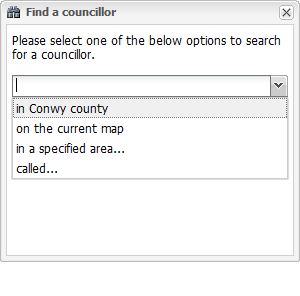
- In Conwy County will search the entire map for councillors, that is, it will find all of them.
- On current map will just search the area displayed in the current map window.
- In a specified area will display additional options which will allow you to draw the area you are interested in.
Drawing options include;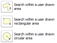
- Called... allows you to enter all or part of a councillors name.
The same principal applies to all council facility searches in that there will be a number of search options available for each category of facility.
The results that are available for each council facility will differ as this is dependant on how much information is available for that facility at that point in time. It is envisaged that the amount of information available will increase as the system develops.
The results that are available for each council facility will differ as this is dependant on how much information is available for that facility at that point in time. It is envisaged that the amount of information available will increase as the system develops.